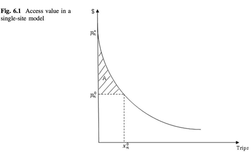
--- Structure of the Results ---
ACTIVITY CAMPSITE EVENT Enabled FACILITYADDRESS FacilityAccessibilityText
1 NULL NULL NULL TRUE NULL
2 NULL NULL NULL TRUE NULL
3 NULL NULL NULL TRUE NULL
4 NULL NULL NULL TRUE NULL
5 NULL NULL NULL TRUE NULL
6 NULL NULL NULL TRUE NULL
FacilityAdaAccess
1 N
2 N
3 N
4 N
5 N
6 N
FacilityDescription
1 <h2>Overview</h2>\n<p><strong>Tuolumne Meadows Campground is closed for the 2025 season.</strong></p><p><strong>Tuolumne Meadows Campground is reopening after three years due to a complete overhaul and rehabilitation of the campsites. Please be mindful of young plants and shrubs by keeping all wheels on parking pads and camping equipment within established campsites. Thank you and welcome back!</strong></p><p>Tuolumne Meadows Campground is located in breathtaking Yosemite National Park in Central California's rugged Sierra Nevada Mountain Range at an elevation of 8,600 feet. The site is situated along the scenic Tioga Road just five miles from the Tioga Pass Entrance Station. Within Yosemite, visitors can gaze upon waterfalls, sheer granite cliffs, deep valleys, grand meadows, ancient giant sequoias, vast wilderness areas, and so much more.</p><p><strong>Reservation Tips! </strong>Campsites in Yosemite are extremely popular and typically sell out in minutes. Login to your account or create a new account before the 7:00 a.m. (PST) release time. You may only add reservations to your cart and proceed with your reservation if you are logged into your account. The recreation.gov call center does NOT have access to additional sites or additional information beyond what is published on recreation.gov.</p><h2>Recreation</h2>\nPopular activities in the area include hiking, rock climbing, backpacking and fishing. The 4.8-mile roundtrip trail to Elizabeth Lake begins in the campground and climbs to a glacier-carved lake at the base of Unicorn Peak. <br/><br/>\nOther trails in Tuolumne Meadows include Soda Springs and Parsons Lodge, Lyell Canyon via the John Muir Trail, Cathedral Lakes, Mono Pass, and Glen Aulin. Nearby Tenaya Lake is a magnificent spot for picnicking, swimming and canoeing.<h2>Facilities</h2>\n<p>This large, popular campground contains family, horse and group camp sites with picnic tables, fire rings, and a food storage lockers. Flush toilets, drinking water, and an amphitheater are provided. Tuolumne Meadows Visitor Center is within walking distance, as is a general store.</p><h2>Natural Features</h2>\nTuolumne Meadows embodies the high-country of the Sierra Nevada, with its broad sub-alpine meadows and granite domes and peaks. The gentle Tuolumne River, Lyell For, and Dana Fork flow through the vast, colorful meadows bursting with seasonal wildflowers. The meadows are surrounded by stands of Western White pine, Mountain hemlock, and Lodgepole pine.\n<h2>Nearby Attractions</h2>\nYosemite Valley, an awe-inspiring landscape containing many of the famous features for which Yosemite National Park is known, is 55 miles and two hours from Tuolumne Meadows. Hiking trails and bike paths are abundant in the valley. Rafting the Merced River is a fun way to cool down on a summer day when water levels are sufficient. Yosemite Valley also offers numerous guided bus tours, educational programs, museums, ranger-led activities, and an art center with workshops.<br/><br/>\nGlacier Point is an hour from Yosemite Valley, with sweeping views of both Yosemite and Little Yosemite Valley, Half Dome, Vernal and Nevada Falls, and Clouds Rest, among other notable landmarks. <br/><br/>\nA visit to Wawona and the Pioneer Yosemite History Center is like stepping back in time.<br/><br/><h2>Charges & Cancellations</h2>\n\nCancellation of individual or equestrian site reservations will be charged a $10 service fee. If the cancellation is within 48 hours of the arrival date, the first night's fee will also be charged.\n\nCancellation of a group site reservation will incur a $10.00 service fee plus the first night’s use fee when the reservation is cancelled within 14 days of the scheduled arrival date. \n\nCancellations for a single night’s use will not be assessed a service fee. \n\nNo-shows for any type of reservation will be charged a $20 service fee and the first night's fee.
2 <h2>Overview</h2>\nTrailhead Group Campground is located in the eastern high Sierra Nevada Mountains of California at just over 10,000 feet in elevation. Also known as Saddlebag Lake Group Campground, the facility is adjacent to the scenic lake and provides a quiet mountain getaway for groups of up to 25 people. It is within a two-hour drive of Yosemite National Park and Mono Lake, and lies next to the Hoover Wilderness.<h2>Recreation</h2>\nCampers might like to relax and unwind by picnicking in the forested camping area or around the lake. The eastern Sierras are well-known for trout fishing, and Saddlebag Lake is no exception. Anglers can access a boat ramp nearby or try their luck for rainbow, brook and brown trout from shore. The lake has a 15 mph speed limit.\n<br/><br/>\nThe majestic scenery and challenging trails are a big draw for hikers. Close by, campers can access the Twenty Lakes Basin Trail, which leads into the Hoover Wilderness.<h2>Facilities</h2>\nOne group area is available for tents only. Flush toilets and picnic tables are provided. The group campground is next to the main Saddlebag Lake Campground, which is a small facility with individual sites available on a first-come, first-served basis. Drinking water is available at the main campground, but not directly in the group camping area.\n<br/><br/>\nThe lake's resort offers a restaurant, camping and fishing supplies and boat rentals.<h2>Natural Features</h2>\nThe campground is situated in a high elevation pine forest next to scenic 600-acre Saddlebag Lake, though not directly on the lake shore. Many species of wildlife call the mountains home, such as black bear, mountain lions, mule deer, pine marten, pika and numerous fish and birds.\n<h2>Nearby Attractions</h2>\nThe Mono Lake area and Yosemite National Park are great day trips, and hikers can access the spectacular scenery of the Hoover Wilderness via nearby trails.\n<br/><br/>\n<a href="http://www.recreation.gov/recAreaDetails.do?contractCode=NRSO&recAreaId=13061&agencyCode=131" rel="nofollow">Hoover Wilderness</a>\n<br/><br/>\n<a href="http://www.nps.gov/yose/index.htm" rel="nofollow">Yosemite National Park</a><h2>Charges & Cancellations</h2>\n<p>Once your reservation start date has begun, neither the Recreation.gov Contact Center nor the campground manager will be able to modify your reservation.</p>\n
3 <h2>Overview</h2>\nThe outstanding lake and mountain views at Oh Ridge Campground make it a favorite spot for both families and anglers. It sits in the eastern Sierra Nevada Mountains in close proximity to the Ansel Adams Wilderness, Yosemite National Park and Mono Lake. The nearby town of June Lake offers the convenience of shopping and dining, while the surrounding land and lakes provide ample outdoor recreation opportunities.<h2>Recreation</h2>\nOh Ridge campers have no problem staying busy and enjoying the outdoors. Within the facility, they can swim in the lake's clear waters, fish for rainbow and Alpers trout, go canoeing and boating or walk to the Oh Ridge viewpoint, after which the campground was named.\n<br/><br/>\nNumerous trails lie minutes away, an obvious draw for hikers, mountain bikers and off-road vehicle enthusiasts. The Fern Lake Trail leads into the scenic Ansel Adams Wilderness. Skiing is a major winter pastime in the area.\n<br/><br/>\nA scenic drive along the June Lake Loop results in expansive views of rugged mountain peaks and several lakes.<h2>Facilities</h2>\nThis is a large facility with campsites organized among several loops named after area animals. The campground is equipped with drinking water and flush toilets, and sites have picnic tables, grills and bear-proof lockers for food storage.\n<br/><br/>\nThe nearby resort offers showers and basic groceries and camping supplies.<h2>Natural Features</h2>\nCampsites are located in a mostly open area above the shoreline of beautiful June Lake. Save for some scattered pine and aspen trees, the campground has little shade. Nearly every point in the facility has a view of the surrounding 11,000-12,000' peaks. The campground's elevation is 7,600 feet.\n<br/><br/>\nMany species of wildlife call the mountains home, such as black bear, mountain lions, mule deer, pine marten, pika and numerous fish and birds.\n<h2>Nearby Attractions</h2>\nMono Lake and its many activities are minutes away. Hikers can access the scenic Ansel Adams Wilderness via nearby trails, and Yosemite National Park is a great day trip.\n<br/><br/>\n<a href="http://www.recreation.gov/recAreaDetails.do?contractCode=NRSO&recAreaId=12842&agencyCode=128" rel="nofollow">Ansel Adams Wilderness</a>\n<br/><br/>\n<a href="http://www.nps.gov/yose/index.htm" rel="nofollow">Yosemite National Park</a><h2>Charges & Cancellations</h2>\n\n<p><strong>Rules & Reservation Policies</strong></p>\n<p>As you make travel plans that include reservations on Recreation.gov, there are standard policies that apply to most locations of which you should be aware. Do keep in mind, however, that there are many exceptions, so it is best to review reservation information listed on individual facility pages for those policies and procedures that pertain to your specific locations.</p>\n\n<p>Any location or activity requiring a permit or lottery will have unique requirements and policies. Please check individual facility pages for pertinent information for those sites.</p>\n\n<p><strong>Booking Window</strong></p>\n<p>For most locations, you can reserve six months in advance of your stay for individual sites and 12 months in advance for group sites. There are some exceptions, so it is best to check with each facility.</p>\n\n<p><strong>Change and Cancellation Policies and Fees</strong></p>\n<p>Overnight and Day Use Facilities: To ensure fairness, reservation arrival or departure dates may not be changed beyond the booking window until 18 days after booking the reservation.</p>\n\n<p>Camping / Day Use: A $10.00 service fee will apply if you change or cancel your reservation (including campsites, cabins, lookouts, group facilities, etc.). The $10.00 service fee will be deducted from the refund amount.</p>\n<p>You can cancel or change reservations through Recreation.gov or by calling 1-877-444-6777.</p>\n<p>Tours & Tickets: You may request changes to tour dates at no cost before the arrival date. If you cancel before your tour date, you may be eligible for a refund. Cancellation fees apply. Please check the tour facility description details page for cancellation policies.</p>\n\n<p>Permits: Varies by location. Please check the permit details for the permit location.</p>\n\n<p><strong>Late Cancellations</strong></p>\n<p>Overnight and Day Use Facilities: Late cancellations are those cancelled between 12:01 a.m. (Eastern) on the day before arrival and check out time on the day after arrival.</p>\n<p>Individual Campsites: If a customer cancels a reservation the day before or on the day of arrival they will be charged a $10.00 service fee and will also forfeit the first night's use fee (not to exceed the total paid for the original reservation). Cancellations for a single night's reservation will forfeit the entire use fee but no cancellation fee will apply.</p>\n<p>Cabins / Lookouts: Customers will be charged a $10.00 cancellation fee and forfeit the first night's use fee if a cabin or lookout reservation is cancelled within 14 days of the scheduled arrival date. Cancellations for a single night's use will not be assessed a service fee.</p>\n<p>Group Facility: If a customer cancels a group overnight facility reservation within 14 days of the scheduled arrival date they will be charged the $10.00 service fee and forfeit the first night's use fee. Cancellations for a single night's use will not be assessed a service fee.</p>\n<p>Group Day Use Area: If a customer cancels a group day use facility reservation within 14 days of the scheduled arrival date, they will forfeit the total day use fee with no service fee charge.</p>\n<p><strong>No-Shows</strong></p>\n<p>Camping / Day Use: A camping no-show customer is one who does not arrive at a campground and does not cancel the reservation by check-out time on the day after the scheduled arrival date. Reserved campsites and group overnight facilities will be held until check-out time on the day following your scheduled arrival. Group day-use facilities will be held until check-in time on your scheduled arrival date.</p>\n\n<p>If a customer does not arrive at the campground or group facility by check-out time the day after arrival or does not cancel the reservation by the times listed under "Late Cancellations" above, the customer may be assessed a $20.00 service fee and forfeit use fees.</p>\n\n<p>Tours: A tour or ticket no-show is one who does not cancel a ticket before arrival and does not arrive for the tour. Tour no-shows are not entitled to a refund.</p>\n\n<p><strong>Refunds</strong></p>\n<p>Customers must request refunds no later than 14 days after the scheduled departure date. Recreation.gov will not grant refund requests after 14 days of departure.</p>\n\n<p>Reservation Fee: For some facilities, tours or permits an additional reservation fee is charged. For some overnight and day-use facilities, an additional non-refundable reservation fee may apply. The non-refundable reservation fee for tours and tickets is $1.00. The non-refundable reservation fee for permits varies by location.</p>\n<p>Refunds for Bankcard Purchases: Refunds for bank card payments will be issued as a credit to the original bank card.</p>\n<p>Refunds for Check or Cash Purchases: Refunds for Recreation.gov payments made by check or money order, and cash payments at selected campgrounds will be issued a check refund. A refund will be processed within 30 days of receipt and approval. Please Note: Refund requests made during or after departure can only be processed when approved by the facility management staff based upon local policy.</p>\n<p>Refunds for Emergency Closures: In the event of an emergency closure, the Recreation.gov team will attempt to notify users and offer alternate dates (as appropriate). If this is not possible, reservations will be cancelled and all fees paid will be refunded. Reservation fees for free tickets are non-refundable in the event of an emergency closure.</p>\n<p>Recreation.gov Billing Information</p>\n<p>Reservation transaction will appear on customer's credit card statements as "Recreation.gov 877-444-6777."</p>\n\n<p>Changes to Policies and Procedures</p>\n<p>Recreation.gov reserves the right, when necessary, to modify reservation policies. These policies were last updated July </p>\n
4 <h2>Overview</h2>\n<p><strong>Crane Valley will be closed the entire 2019 - 2028 camping season due to a massive hazard tree removal </strong><br><br>Crane Valley Group Campground is located adjacent to Bass Lake and can accommodate up to 7 groups with tents and RVs. The facility is shaded by a dense forest of oak, cedar and pine trees, and although none of the sites offer direct views of the lake, the campground offers convenient access to the many recreational activities and attractions in the area.</p>\n<h2>Recreation</h2>\nActivities on Bass Lake include motorized and non-motorized boating, fishing, swimming, hiking, sailing and water skiing. California Land Management sponsors \na variety of interpretive programs throughout the summer at several locations in the Bass Lake area. \n<h2>Facilities</h2>\nThis group campground has 7 sites that can accommodate between 12 to 30 people each. Each site has grills, fire rings and tables. Portable toilets are provided, but campers must bring drinking water. \n<h2>Natural Features</h2>\nThe Sierra National Forest, located on the western slope of the central Sierra Nevada, is known for its spectacular mountain scenery and abundant natural \nresources.<br/><br/>\nThe terrain includes rolling, oak-covered foothills, heavily forested middle elevation slopes and the starkly beautiful alpine landscape of the High Sierra.\n<h2>Nearby Attractions</h2>\nYosemite National Park is under an hour away and makes an ideal day trip from Crane Valley Campground.
5 <h2>Overview</h2>\n<p><strong>Texas Flats Campground remains closed due to hazard trees.</strong></p>\n<p>Texas Flats Campground is a horse-friendly group camp situated on the banks of McGilvery Creek. It is split into 4 sections named manzanita, red fir, white fir and cedar.</p>\n<h2>Recreation</h2>\nNearby logging and forest roads can be used as equestrian trails. The Shadow of the Giants, a popular 1-mile hike through a grove of giant sequoias, is just a short drive northwest of the campground.<h2>Facilities</h2>\nEach campsite can accommodate between 20-30 people and has picnic tables and campfire rings. Vault toilets are provided, but campers need to bring drinking water. This campground does not have facilities or corrals for horses.<h2>Natural Features</h2>\nThe Sierra National Forest, located on the western slope of the central Sierra Nevada, is known for its spectacular mountain scenery and abundant natural resources. The terrain includes rolling, oak-covered foothills, heavily forested middle elevation slopes and the starkly beautiful alpine landscape of the High Sierra.\n<br/><br/>\nTexas Flat Campground is located in the Highway 41 Corridor of the Bass Lake Ranger District. This area is known for the Nelder Grove of giant sequoias.\n<h2>Nearby Attractions</h2>\nYosemite National Park is a popular day trip. Visitors can also take a ride on the historic logging train at Yosemite Mountain Sugar Pine Railroad.\n<br/><br/>\nThe Sierra Vista Scenic Byway (Sky Ranch Road), an 83-mile drive past some of the highlights of Sierra National Forest, runs nearby.
6 <h2>Overview</h2>\nChilkoot is named for the creek that runs by the campground. The facility is shaded by a grove of Ponderosa pine, fir and cedar, and offers ample space for tent or RV camping. <br/><br/> \nThis campground is located at an elevation of approximately 4,600 feet, providing a comfortable camping experience during the hottest days of summer.<h2>Recreation</h2>\nA popular recreation and resort area is a few miles away at Bass Lake. Activities here include motorized and non-motorized boating, fishing, swimming, hiking, sailing and water skiing.<br/><br/> \n\nAnglers can fish in Chilkoot Creek for channel catfish, sucker and brown trout. Other nearby activities include hiking the Buena Vista trail and paddling on Willow Creek.<h2>Facilities</h2>\nThis rustic campground provides a host and vault toilets but no water. Each unit has a gravel parking spur, picnic table and fire ring. Some sites are located on slopes and are not suitable for tents, while other sites are tent only.<h2>Natural Features</h2>\nThe Sierra National Forest, located on the western slope of the central Sierra Nevada, is known for its spectacular mountain scenery and abundant natural \nresources.<br/><br/>\n\nThe terrain includes rolling, oak-covered foothills, heavily forested middle elevation slopes and the starkly beautiful alpine landscape of the High Sierra.\n<h2>Nearby Attractions</h2>\nYosemite National Park can be reached in under an hour from Chilkoot Campground. The South Fork of the Merced River is also nearby, which is popular for whitewater rafting.<h2>Charges & Cancellations</h2>\n<p>Once your reservation start date has begun, neither the Recreation.gov Contact Center nor the campground manager will be able to modify your reservation.</p>\n
FacilityDirections
1 <p>Take Highway 41 north from Fresno, Highway 140 east from Merced, Highway 120 east from Manteca or west from Lee Vining (State Route 395) into Yosemite National Park. Tuolumne Meadows Campground is located 5 miles from the Tioga Pass Entrance station (Hwy 120 from the east), and is 55 miles (2 hours) from Yosemite Valley.</p><p><strong>OVERFLOW PARKING: </strong>Many sites in Tuolumne Meadows Campground can only accommodate one single vehicle. There is overflow parking available at the Parson's Lodge Trailhead Parking as well as the parking lot directly West of the Tuolumne Meadows Grill and Store (the old gas station lot). Limited parking is also available on the side of the Soda Springs Road past Lembert Dome Trailhead parking. Lembert Dome Parking lot is <em>NOT</em> available for overnight parking. </p>
2 Take U.S. Highway 395 in California to its junction with State Highway 120 west. Take 120 west 10 miles toward Tioga Pass. Turn right on Forest Road 1N04 to Saddlebag Lake. Proceed up 1N04 for 2.4 miles. Take the first right just past the open gate on the road. The campground is on the right, just past the restroom.
3 Oh Ridge Campground is 350 miles north of Los Angeles and 150 miles south of Reno, Nevada. Take U.S. Highway 395 to its southern junction with Highway 158. Take 158 for 1 mile. Turn right on North Shore Drive. Go approximately 1 mile and turn left on Pine Cliff Road. Go 0.5 mile to campground entrance.
4 From Fresno, California, take Highway 41 north through Oakhurst. Turn\nright on Forest Road 222, towards Bass Lake. Keep right for 3.5 miles to\nthe campground.
5 Take Highway 41 north through Oakhurst past Rd. 222 (aka Bass Lake turn off), to Road 632 (aka Sky Ranch Road). <br/>\nTurn right, travel 7 miles, and turn right on FS6S40 towards Soquel Campground. <br/>\nTravel for 1 mile, turn left on 6S08, cross the bridge and continue left through Greys Mt. Campground. <br/>\nTravel for 1 mile, turn left on 6S38, and continue for 2 miles to Texas Flat Campground. (Distances approximate). \n
6 Directions from Fresno: Take Highway 41 through Oakhurst, California. Turn east on Forest Road\n222 (Bass Lake turnoff) and continue on for 7 miles. Turn left onto Beashore Road, follow Beashore Road for 4 miles to the Chilkoot Campground.
FacilityEmail FacilityID FacilityLatitude FacilityLongitude
1 232448 37.87111 -119.3600
2 clm@clm-services.com 232422 37.96433 -119.2723
3 clm@clm-services.com 232269 37.79750 -119.0747
4 clm@clm-services.com 232909 37.33328 -119.5861
5 clm@clm-services.com 232879 37.42545 -119.5445
6 clm@clm-services.com 232882 37.36749 -119.5374
FacilityMapURL FacilityName
1 Tuolumne Meadows Campground
2 Saddlebag Lake Trailhead Group Camp
3 OH RIDGE
4 CRANE VALLEY
5 TEXAS FLATS
6 CHILKOOT
FacilityPhone FacilityReservationURL FacilityTypeDescription
1 209-372-4025 OR 209-372-8502 Campground
2 Campground
3 760-648-7744 Campground
4 559-642-3212 Campground
5 559-642-3212 Campground
6 Campground
FacilityUseFeeDescription
1
2
3
4
5
6
Keywords
1 Yosemite National Park
2 TRAG,SADDLEBAG LAKE GROUP CAMP,INYO NF - FS
3 OHRI,INYO NF - FS
4 CRVA,BASS LAKE OAKHURST AR,SIERRA NF - FS
5 TEXA,MANZANITA GROUP,WHITE FIR GROUP,RED FIR GROUP,CEDAR GROUP,SIERRA NF - FS
6 CHKO,SIERRA NF - FS
LINK LastUpdatedDate LegacyFacilityID
1 NULL 2025-10-24 70926
2 NULL 2025-07-11 70832
3 NULL 2025-08-04 70565
4 NULL 2025-07-11 71719
5 NULL 2025-07-11 71667
6 NULL 2025-07-11 71670
MEDIA
1 NPS/EBissmeyer, NPS/EBissmeyer, NPS/EBissmeyer, NPS/EBissmeyer, NPS, NPS, NPS, Share the Experience, Sharon Soberon, NPS, Entrance to Backpackers Camp, tent in a campsite, Clouds Rest sunset, Tuolumne campsite 24H, campground map, Tuolumne Campground Reservation Office, Tuolumne River, Lembert Dome in the background, Yosemite National Park, Tuolumne Meadows, View of the Tuolumne River and Lembert Dome, , , , , , , , , , 232448, 232448, 232448, 232448, 232448, 232448, 232448, 232448, 232448, 2a48a566-4eb8-4565-933e-7094a2721e43, 4d8c3fe0-5edb-4cef-ade7-d50ddca00c41, f2227189-2916-4f8e-937d-19e36394b524, 2fa488e7-ebbd-48bc-9689-1c53b4dc1e77, 61468c91-f285-4afe-9855-cd98e7784509, 2572433, 2572393, 07fc0b0a-330b-4a66-acaf-edca98b366e4, 2572316, Facility, Facility, Facility, Facility, Facility, Facility, Facility, Facility, Facility, 525, 525, 908, 525, 875, 526, 526, 340, 526, TRUE, FALSE, TRUE, TRUE, TRUE, TRUE, TRUE, FALSE, TRUE, FALSE, TRUE, FALSE, FALSE, FALSE, FALSE, FALSE, FALSE, FALSE, FALSE, FALSE, FALSE, FALSE, FALSE, FALSE, FALSE, TRUE, FALSE, Image, Image, Image, Image, Image, Image, Image, Image, Image, , , , , , , , , , Entrance to Backpackers Camp., tent in a campsite, Clouds Rest sunset, Tuolumne campsite 24H, campground map, TUOLUMNE MEADOWS Campground Office, TUOLUMNE MEADOWS Tuolumne River, Yosemite National Park, TUOLUMNE MEADOWS Lembert Dome, https://cdn.recreation.gov/public/2025/08/05/05/53/232448_2311f358-b58b-40a6-a5c9-ee83cc32fff4_700.webp, https://cdn.recreation.gov/public/2025/08/05/05/50/232448_422d8aa3-1071-4e8b-984c-96c5ffca38a9_700.webp, https://cdn.recreation.gov/public/2025/01/14/05/19/232448_ed779ec4-aa75-4d6b-82da-79830a594bb1_1440.webp, https://cdn.recreation.gov/public/2025/01/14/05/24/232448_9b48004d-b42a-4de5-9a35-5dc433e5ef72_700.webp, https://cdn.recreation.gov/public/2025/08/05/05/44/232448_32f59bb2-d32c-4776-b777-21cc56b451c2_1440.webp, https://cdn.recreation.gov/public/images/65928_700.webp, https://cdn.recreation.gov/public/images/65886_700.webp, https://cdn.recreation.gov/public/2018/09/13/17/05/232448_93e7d5fd-15b8-4748-a193-b18d3bbf5d23_1440.webp, https://cdn.recreation.gov/public/images/65805_700.webp, 700, 700, 1440, 700, 1440, 700, 700, 1440, 700
2 Staff, Staff, , Trailhead Group Area, Photo of group area , , , , , 232422, 232422, 232422, debdb524-ea62-44a0-b5c5-401791ec318a, 6b4a27c1-faf0-4fd2-9416-c6aa7bf881a1, 2572243, Facility, Facility, Facility, 525, 810, 957, TRUE, FALSE, TRUE, FALSE, FALSE, FALSE, FALSE, TRUE, FALSE, Image, Image, Image, , , , Trailhead Group Campground, Trailhead Group , TRAILHEAD GROUP, https://cdn.recreation.gov/public/2023/03/01/21/17/232422_5dc5cf56-b39b-40cb-90c8-26737923bf51_700.webp, https://cdn.recreation.gov/public/2023/03/01/21/15/232422_d71a79b0-72df-4a13-96ed-75787cd50536_1440.webp, https://cdn.recreation.gov/public/images/65746_1440.webp, 700, 1440, 1440
3 CLM, CLM, CLM, , CLM, CLM, CLM, Oh Ridge Campground, Oh Ridge Campground, Oh Ridge Campground, , Oh Ridge Campground, Oh Ridge Campground, Oh Ridge Campground, , , , , , , , 232269, 232269, 232269, 232269, 232269, 232269, 232269, 2571469, 1f8e3d7b-7f5b-4026-8547-b418d272000f, e37d6768-3f74-4a0f-9bda-cfe38686e5bb, 2571353, 2571531, 2571498, 2571496, Facility, Facility, Facility, Facility, Facility, Facility, Facility, 957, 340, 525, 973, 957, 957, 822, TRUE, FALSE, TRUE, TRUE, TRUE, TRUE, TRUE, FALSE, FALSE, FALSE, FALSE, FALSE, FALSE, FALSE, FALSE, TRUE, FALSE, FALSE, FALSE, FALSE, FALSE, Image, Image, Image, Image, Image, Image, Image, , , , , , , , Oh Ridge Campground, Oh Ridge Campground, Oh Ridge Campground, OH RIDGE, Oh Ridge Campground, Oh Ridge Campground, Oh Ridge Campground, https://cdn.recreation.gov/public/images/64991_1440.webp, https://cdn.recreation.gov/public/2019/02/11/23/45/232269_b0917550-b166-4dac-9b79-72a2035e8e0c_1440.webp, https://cdn.recreation.gov/public/2019/02/11/23/52/232269_ebc10959-c028-4d13-b2e4-5deb6d22c0d4_700.webp, https://cdn.recreation.gov/public/2019/02/11/23/53/232269_9a4b8626-7ecc-4899-a1c3-f75111887ec4_1440.webp, https://cdn.recreation.gov/public/images/65064_1440.webp, https://cdn.recreation.gov/public/images/65024_1440.webp, https://cdn.recreation.gov/public/images/65022_1440.webp, 1440, 1440, 700, 1440, 1440, 1440, 1440
4 , USFS, USFS, , , , , , Crane Valley Campground, Crane Valley Campground, , , , , , , , , , , , 232909, 232909, 232909, 232909, 232909, 232909, 232909, 2574065, 4a9cdb75-14d0-475e-ba6b-657406b0c9c2, 9b432399-6e19-4d25-b6ad-aecea9455081, 2574069, 2574067, 2574064, 2574066, Facility, Facility, Facility, Facility, Facility, Facility, Facility, 944, 811, 526, 1065, 957, 955, 951, TRUE, FALSE, FALSE, TRUE, TRUE, TRUE, TRUE, FALSE, FALSE, TRUE, FALSE, FALSE, FALSE, FALSE, FALSE, TRUE, FALSE, FALSE, FALSE, FALSE, FALSE, Image, Image, Image, Image, Image, Image, Image, , , , , , , , CRANE VALLEY, A picnic table in a forest grove, Picnic tables and fire rings at campsites in a forest grove, CRANE VALLEY, CRANE VALLEY, CRANE VALLEY, CRANE VALLEY, https://cdn.recreation.gov/public/images/75236_1440.webp, https://cdn.recreation.gov/public/2024/01/12/15/51/232909_1ae8a119-495c-4f9e-8e59-106c30cec4d6_1440.webp, https://cdn.recreation.gov/public/2024/01/12/15/52/232909_fd1d6d71-db69-4dfa-bf53-26a2eeef13ee_700.webp, https://cdn.recreation.gov/public/images/75240_700.webp, https://cdn.recreation.gov/public/images/75238_1440.webp, https://cdn.recreation.gov/public/images/75235_1440.webp, https://cdn.recreation.gov/public/images/75237_1440.webp, 1440, 1440, 700, 700, 1440, 1440, 1440
5 USFS, USFS, , , , , , Texas Flats Group Camp, Texas Flats Campground, , , , , , , , , , , , , 232879, 232879, 232879, 232879, 232879, 232879, 232879, f4c3d1be-3790-4ecf-af71-d84bf9ad0f12, 4ec779c9-58bb-4b1a-bb21-350a19fbedab, 2573822, 2573819, 2573821, 2573818, 2573672, Facility, Facility, Facility, Facility, Facility, Facility, Facility, 526, 811, 957, 957, 957, 957, 957, FALSE, FALSE, TRUE, TRUE, TRUE, TRUE, TRUE, TRUE, FALSE, FALSE, FALSE, FALSE, FALSE, FALSE, FALSE, TRUE, FALSE, FALSE, FALSE, FALSE, FALSE, Image, Image, Image, Image, Image, Image, Image, , , , , , , , A brown and yellow Forest Service sign for Texas Flats Group Camp, Picnic tables and logs under a grove of trees, TEXAS FLATS, TEXAS FLATS, TEXAS FLATS, TEXAS FLATS, TEXAS FLATS, https://cdn.recreation.gov/public/2024/01/24/15/44/232879_6d87624a-fc35-44db-a4c8-ae674fc41dd0_700.webp, https://cdn.recreation.gov/public/2024/01/24/15/43/232879_ab08793d-4e12-49d9-a1f8-e1404c3f64ab_1440.webp, https://cdn.recreation.gov/public/images/75204_1440.webp, https://cdn.recreation.gov/public/images/75201_1440.webp, https://cdn.recreation.gov/public/images/75203_1440.webp, https://cdn.recreation.gov/public/images/75200_1440.webp, https://cdn.recreation.gov/public/images/66946_1440.webp, 700, 1440, 1440, 1440, 1440, 1440, 1440
6 USFS, USFS, Entry Sign, Entry Sign, , , 232882, 232882, c6a51777-e2b3-422b-a4e5-a0d3c6849157, d0bba74b-89f5-42ae-915c-5d5dbd2330d9, Facility, Facility, 810, 525, FALSE, FALSE, FALSE, TRUE, TRUE, FALSE, Image, Image, , , A brown and yellow Forest Sign for Chilkoot Campground on the Sierra National Forest, A brown and yellow Forest Sign for Chilkoot Campground on the Sierra National Forest, https://cdn.recreation.gov/public/2024/01/12/15/41/232882_d0e4990b-ad8a-47b5-ab18-4738ca1b47a3_1440.webp, https://cdn.recreation.gov/public/2024/01/12/15/39/232882_19e8e4de-712e-4a64-a0a3-89399b11d507_700.webp, 1440, 700
ORGANIZATION OrgFacilityID PERMITENTRANCE ParentOrgID ParentRecAreaID RECAREA
1 NULL AN370926 NULL 128 2991 NULL
2 NULL AN370832 NULL 131 1064 NULL
3 NULL AN370565 NULL 131 1064 NULL
4 NULL AN371719 NULL 131 1074 NULL
5 NULL AN371667 NULL 131 1074 NULL
6 NULL AN371670 NULL 131 1074 NULL
Reservable StayLimit TOUR GEOJSON.COORDINATES GEOJSON.TYPE
1 TRUE NULL -119.36000, 37.87111 Point
2 TRUE NULL -119.27231, 37.96433 Point
3 TRUE NULL -119.0747, 37.7975 Point
4 TRUE NULL -119.58607, 37.33328 Point
5 TRUE NULL -119.54448, 37.42545 Point
6 TRUE NULL -119.53736, 37.36749 Point